

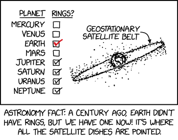
Title text:
If you don’t know where you are on Earth, the angle of satellite dishes can help constrain your latitude. If some of them are pointing straight up, you’re probably near the Equator, right under the ring.
Transcript:
Transcript will show once it’s been added to explainxkcd.com
Source: https://xkcd.com/3156/
You must log in or # to comment.
Hey I am into this! Check out this site I built for tracking satellites!
I’d appreciate if I could use your website without advertisement cookies. Would you mind complying with EU cookie law?
I’m not familiar, what is the law, that we cannot use authentication cookies or google/twitter analytics cookies?
Thats so cool! Looks loke the most popular orbit aligns with the equator. Why is the wider “belt” around that line going over and under? Like
     .
    ..
   ...
------
...
..
.
You know what I mean?
From what I could find that’s probably the band of decommissioned geosynchronous satellites. Apparently they’ll slowly match the orbital plane of the earth around the sun.
those are mostly red and orange, so that also confirms the other comments’ guesses:


I browsed for a while and then realized, holy shit, they’re moving. Is this real-time? Either way, this is awesome.
Wow thanks so much!
Yes, so I’m taking every telescope/radio/radar reading I’m allowed to redistribute and then collecting them into a time series database and fetching the most recent reading for each sat into a text file. That’s the TLE download in the public API. Then I use Rust WASM to propagate those readings into positions that are synced with the viewer time. This allows us to very roughly forecast where they will be for the next couple days.
It’s cool because it’s too much data to transfer over the network, so we only transfer the most recent reading and then calculate positions live in the browser.
Where are the Lagrange points?


